July 21-22, 2023 – Lander, WY
.jpg)
We left Yampa Valley Fiberworks on Friday morning but did not get very far before we blew a front tire on the Jeep. Luckily there was a wide enough shoulder that we could pull off the road. It was the driver’s side front tire that blew so Rex had to change the tire on the traffic side. There was not a lot of traffic but enough to make it uncomfortable because most of the vehicles did not even slow down. To make matters worse, one of the vehicles threw up a rock that shattered the back window in the Jeep. So now this is what our poor Jeep looks like.
.jpg)
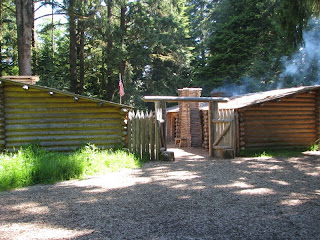
We are staying at The Mountain Range RV Park on the
edge of Lander.
.jpg)
This is a very nice small park with wonderful views of the surrounding mountains.
We found a tire store and ordered new tires. We also found a glass shop that looked at the Jeep window but because our top is an after-market top with no brand name, they could not order a window for us. They said they could custom make a window, but it would take about 3 weeks. We finally agreed that our best option would be for them to fabricate a temporary Plexiglass-type window and then we can get a permanent window when we get back to Arizona in October. They could not get us in until Thursday so as we have reservations at an RV park in Dubois on Sunday, we will come back on Thursday to get our tires mounted and the temporary window installed.
.jpg)
Saturday afternoon, we took a Jeep drive to Sinks Canyon State Park, the Loop Road and South Pass City State Historic Site. Our first stop was in Sinks Canyon State Park at “The Sinks”. “The Sinks” are a series of cracks and crevices at the back of the cavern. The water of the Popo Agie River flows into the Sinks. It then reappears at the “Rise of the Sinks”, a large calm pool ¼ mile down canyon.
.jpg)
The Sinks are eroded into the soft white Madison
Limestone formation. No spelunkers have
explored very far into the Sinks since the cracks narrow down to very small log
and rock choked passages.
Tacky and Rex enjoying the Sinks.
.jpg)
We saw this deer on the path to the “Rise of the
Sinks”.
For many years it was unknown whether the water flowing into the Sinks was the same water flowing out at the Rise. Dye tests have proven the connection but have also revealed another mystery. It takes the water flowing into the Sinks over 2 hours to reappear at the Rise. It was also discovered that more water flows out at the Rise than goes in at the Sinks. Why the water takes over two hours to make the journey and where it goes during that time is still a mystery.
.jpg)
The Popo Agie River is an excellent trout stream with brown and rainbow trout. As the trout migrate upstream looking for suitable spawning areas, the Rise acts as a natural barrier to any further upstream movement. The trout in the Rise arrived there naturally and stay because it is a protected area with an extensive food supply. The pool is deep enough and there is enough year-round water flow that it never freezes. Some of the trout in the pond weigh 8-10 lbs.
.jpg)
There are dispensers that give you a handful of fish food for a quarter. The children at the site enjoyed throwing food in the pond and watching the “feeding frenzy. It is no wonder that the fish are so big here!
.jpg)
We drove up through this beautiful canyon and then drove The Loop Road, a 26-mile winding road in the Shoshone National Forest. The first 7 miles was very winding with many switch back curves. This is looking back down at one of the curves.
.jpg)
We stopped at Worthen Reservoir and walked down to the water.
The views of the Wind River Mountains were magnificent.
.jpg)
This beautiful flower was on the path we took to the water. We think it is a Bitterroot.
The pavement ended here but the gravel road was fairly
good, but rough. The drive was beautiful
and took us past Frye, Fiddlers, and Louis Lakes.
.jpg)
The Loop Road ended at Highway 28, and we drove a
short distance to South Pass City State Historic Site. Rumors of gold discoveries along the Sweetwater
River date to the 1840’s. The first sizable discovery in the South Pass region
was by a party of men out of Fort Bridger called the Cariso Lode (later called
the Carissa) in June 1867. This is the
Carissa Mine & Mill.
.jpg)
South Pass City was founded in the initial gold rush in 1868 and exploded into life with a population of 2000. In 1869 the population grew to around 3000 and South Pass City was the 2nd largest town in the Wyoming Territory. The State of Wyoming has restored over 30 buildings.
.jpg)
The Mercantile had hundreds of cans with replicas of
the original labels. The owner was also
the postmistress, so the post office was in the rear of the store.
.jpg)
Willow Creek runs through town. South Pass City is fun to walk through and
try to imagine what it was like during the gold rush.

After leaving South Pass City we drove to South Pass. Indians, mountain men, Oregon Trail
emigrants, Pony Express riders, and miners all recognized the value of this
passageway straddling the Continental Divide.
Bounded by the Wind River Range on the north and the Antelope Hills on
the south, the pass offered overland travelers a broad, relatively level
corridor between the Atlantic and Pacific watersheds.
.jpg)
On the way back to Lander we drove down Red Canyon Road into the beautiful Red Canyon. Back on the highway we stopped at the overlook and was able to get a picture of almost the entire canyon. You can see the 4-wheel drive road we were on.
We had a great day seeing some of
this beautiful area in Wyoming. We enjoyed
our few days in Lander and think we should have planned more time here.
.JPG)

Comments
Post a Comment