October 1-5, 2011 – Flagstaff, AZ
We left Chama on Saturday, October 1st and headed to Flagstaff, AZ. Just outside of Chama a small herd of elk ran across the road in front of us. The calf fell in the middle of the road but was able to get up quickly. By the time Nancy got the camera out and ready they were all across the road and jumping the fence.
After a long drive (about 8 hours) we arrived in Flagstaff in the rain. We are staying at Greer’s Pine Shadows in a Ponderosa Pine forest just North of Flagstaff. This is a no frills campground – it does not even have bathrooms and showers but will be fine for us for a few days.
Sunday morning we hiked a trail in the forest behind the campground and after lunch we visited the Flagstaff Visitor Center.
For years volcano climbing visitors scarred and damaged the crater until it was closed to climbers. It is now recovering and plant life is slowly returning to the damaged areas.
We were able to see a variety of formations caused by the lava flow.
This was one of the most rugged and picturesque lava flows we have seen. We really enjoyed our visit to Sunset Crater Volcano National Monument.
We continued about 25 miles north to Wupatki National Monument which protects the ancient dwellings of puebloan peoples who lived here between 1100 and 1250.
After looking at the displays in the visitor center we took a short hike to Wupatki Pueblo.
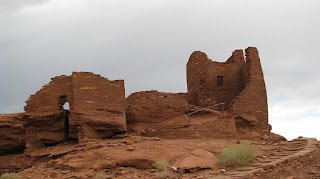
Wupatki Pueblo is a multi-level, high-rise is the largest dwelling in the area and had about 100 rooms.
We were able to climb up into this pueblo and walk around in it. We were amazed at how precisely the rocks were cut to form sharp corners.
Farther down the road we stopped at Citadel Pueblo. The buildings at the base of Citadel Pueblo had a few walls standing but the main ruin was mostly rubble.
We were really impressed with the quality of the ruins here at Wupatki National Monument.
On the way back to Flagstaff we took a detour around the back side of the San Francisco Peaks. The road was rough but the scenery was beautiful. The aspens were starting to turn but were not as far along as they were at Chama.
 Walnut Canyon is a beautiful, deep and narrow canyon where the Sinagua people lived in cliff dwellings between 1125 and 1250. The Sinagua grew corn, beans, squash on the canyon rim and lived in cliff dwellings on both sides of the canyon. Theft of artifacts and destruction of the ruins in the 1880’s prompted local efforts to preserve the canyon and in 1915 Walnut Canyon was declared a national monument.
After looking through the Visitor Center and watching a short movie about the canyon and the Sinagua, we walked the Island Trail which descends 185 feet into the canyon. We got some great views of dwellings across the canyon. There were dwellings on two different levels all the way up and down the canyon.
The trail passes 25 of the cliff dwelling rooms – some are more intact than others. It was great to be able hike close to these ruins and visualize what it must have been like living here. Quite a hike down to the canyon floor for water and up to the rim to tend crops!
We enjoyed this trail very much and are amazed that people lived here in these conditions. We were pretty winded by the time we hiked back up out of the canyon and decided that if we did it every day we would be in great shape.
After we left Walnut Canyon we took a short drive to Arizona Snowbowl, the local ski resort. The resort was closed and it started raining so we headed back to the 5th wheel. We have enjoyed our time in Flagstaff but a storm is coming in tomorrow and they are predicting the “S” word - SNOW - for Thursday and Friday. We will head out Thursday morning for a lower elevation to avoid the snow and spend a week at Camp Verde and the Sedona area.
After a long drive (about 8 hours) we arrived in Flagstaff in the rain. We are staying at Greer’s Pine Shadows in a Ponderosa Pine forest just North of Flagstaff. This is a no frills campground – it does not even have bathrooms and showers but will be fine for us for a few days.
Sunday morning we hiked a trail in the forest behind the campground and after lunch we visited the Flagstaff Visitor Center.
Monday, October 3rd, we drove to Sunset Crater Volcano National Monument north of Flagstaff. Sunset Crater is the most recent volcanic activity in the Flagstaff area erupting about 1000 years ago leaving a 1000 ft high volcanic cone. In 1928 some filmmakers wanted to create a landslide at Sunset Crater. Fearing irreversible damage to the crater, area residents pushed for protection of the area. In 1930 President Hoover established Sunset Crater National Monument. The name was later changed to Sunset Crater Volcano National Monument (although the sign still has the old name).
For years volcano climbing visitors scarred and damaged the crater until it was closed to climbers. It is now recovering and plant life is slowly returning to the damaged areas.
We hiked the Lenox Crater trail which goes straight up the side of the cinder cone crater. The trail gains 300 feet in elevation in the mile to the top. After some huffing and puffing we made it to the top where we could look down into the shallow crater. We also got a great view of the San Francisco Peaks in the distance. We learned that the San Francisco Peaks was at one time a single crater of a large volcano.
After an easy hike back down we drove a short distance to the Lava Flow Trail as the base of Sunset Crater. We hiked the mile long trail into and around the lava flow.
We were able to see a variety of formations caused by the lava flow.
This dead Aspen tree on the cliff stood out against the black lava rock.
This was one of the most rugged and picturesque lava flows we have seen. We really enjoyed our visit to Sunset Crater Volcano National Monument.
We continued about 25 miles north to Wupatki National Monument which protects the ancient dwellings of puebloan peoples who lived here between 1100 and 1250.
After looking at the displays in the visitor center we took a short hike to Wupatki Pueblo.
Wupatki Pueblo is a multi-level, high-rise is the largest dwelling in the area and had about 100 rooms.
We were able to climb up into this pueblo and walk around in it. We were amazed at how precisely the rocks were cut to form sharp corners.
Farther down the road we stopped at Citadel Pueblo. The buildings at the base of Citadel Pueblo had a few walls standing but the main ruin was mostly rubble.
We were really impressed with the quality of the ruins here at Wupatki National Monument.
On the way back to Flagstaff we took a detour around the back side of the San Francisco Peaks. The road was rough but the scenery was beautiful. The aspens were starting to turn but were not as far along as they were at Chama.
 Walnut Canyon is a beautiful, deep and narrow canyon where the Sinagua people lived in cliff dwellings between 1125 and 1250. The Sinagua grew corn, beans, squash on the canyon rim and lived in cliff dwellings on both sides of the canyon. Theft of artifacts and destruction of the ruins in the 1880’s prompted local efforts to preserve the canyon and in 1915 Walnut Canyon was declared a national monument.
After looking through the Visitor Center and watching a short movie about the canyon and the Sinagua, we walked the Island Trail which descends 185 feet into the canyon. We got some great views of dwellings across the canyon. There were dwellings on two different levels all the way up and down the canyon.
The trail passes 25 of the cliff dwelling rooms – some are more intact than others. It was great to be able hike close to these ruins and visualize what it must have been like living here. Quite a hike down to the canyon floor for water and up to the rim to tend crops!
We enjoyed this trail very much and are amazed that people lived here in these conditions. We were pretty winded by the time we hiked back up out of the canyon and decided that if we did it every day we would be in great shape.
After we left Walnut Canyon we took a short drive to Arizona Snowbowl, the local ski resort. The resort was closed and it started raining so we headed back to the 5th wheel. We have enjoyed our time in Flagstaff but a storm is coming in tomorrow and they are predicting the “S” word - SNOW - for Thursday and Friday. We will head out Thursday morning for a lower elevation to avoid the snow and spend a week at Camp Verde and the Sedona area.


.JPG)

Comments
Post a Comment